GPS doesn’t work indoors. UNav does.
UNav turns ordinary buildings into navigable digital twins. Using only a smartphone, visitors can instantly determine where they are and receive turn-by-turn directions through hospitals, transit stations, campuses, stadiums, and other complex spaces—without beacons or new infrastructure.
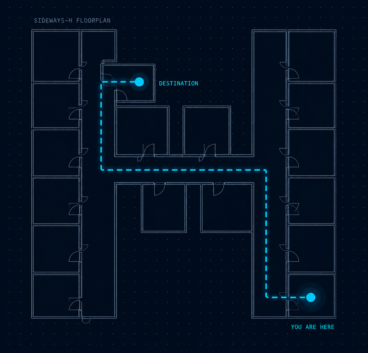
Map a building. Enable navigation everywhere.
UNav builds its maps from ordinary video, not LiDAR or fixed beacons. A single handheld camera captures a space; our models do the rest.
Capture
A single GoPro records a rapid 360° walkthrough of the space — no scanning rig or facility shutdown required.
Digitize
UNav's servers process the footage into a precise digital twin of the floor, accurate to within a percent of LiDAR.
Position
A user opens the app and snaps one photo. UNav matches it against the twin to pinpoint their exact location.
Guide
They choose a destination and follow turn-by-turn directions across floors, indoors and out, continuously.
Built for the people running the building, and the people trying to find their way through it.
Getting lost is not a minor inconvenience. It costs facilities time, money, and trust, and it costs visitors stress at moments that are often already difficult.
Recover the time wayfinding failures quietly drain
- ●Fewer missed and delayed appointments, with rooms and equipment used as scheduled
- ●Less staff time spent walking visitors to where they need to go
- ●Higher utilization of high-value spaces like operating rooms and exam suites
- ●Improved visitor satisfaction scores tied to the overall experience
- ●Live in 24 hours, with no construction, beacons, or IT infrastructure to install
A clear path, from the front door to the exact destination
- ●Turn-by-turn directions that work seamlessly between outdoor approach and indoor hallways
- ●Confidence walking into an unfamiliar building, without needing to ask staff for directions
- ●Less time spent lost and more time for the appointment, class, or visit itself
- ●Guidance that adapts to individual needs through touch, sound, and visual cues
- ●Available on the phone they already carry, no special hardware to pick up
Designed first for healthcare. Built to extend further.
UNav's beachhead is large academic medical centers, where the cost of getting lost is highest. The same platform extends naturally to any complex public space.
Specialty and cancer centers
Large hospital campuses with multiple buildings and departments, where patients arriving for time-sensitive treatment can least afford to get lost.
Outpatient and specialty clinics
High foot-traffic outpatient buildings where clear wayfinding keeps appointment schedules on track and exam rooms turning over on time.
Accessibility-focused facilities
Organizations like Lighthouse Guild and special education institutes, where Sensory+ navigation modes are core to the mission, not an add-on.
University campuses
Sprawling academic campuses where new students, visiting families, and guest speakers need a fast way to find their way between buildings.
Subway and transit stations
Dense underground environments with no GPS signal, where indoor-outdoor continuity matters most for daily commuters and infrequent riders alike.
Museums and civic buildings
Large public buildings serving visitors of every age and ability, from museum-goers tracking an exhibit route to residents navigating a courthouse.
Navigation that adapts to the person, not the other way around.
Sensory+ blends touch, sound, and visual cues based on each person's preference, built alongside disability and rehabilitation researchers from day one rather than retrofitted later.
This panel previews how the same instruction is delivered differently depending on the mode selected. In the app, all three can combine for one continuous experience.
Navigation gets richer every year, accessibility stays built in.
Sensory+ modes are available across every tier of the platform as it grows from basic positioning to full augmented-reality guidance.
Find your way
- Initial positioning
- Surroundings & limited points of interest
- 2D map routing, single and multi-floor
Stay on track
- Turn-by-turn trip monitoring
- Expanded points of interest
- 3D map routing and basic re-routing
See it before you arrive
- Augmented reality navigation
- Real-time re-routing with object recognition
- Automatic start-point detection
A team built across operations, engineering, medicine, and science.

Jason Magesis
CEO & COO20+ years in financial services and operations, leading PathLogic's product roadmap and commercialization strategy.

Pranjal Mittal
CTO & Lead EngineerOver a decade of software engineering and product experience at Amazon and GoodRx, from early stage through IPO.

John-Ross Rizzo
Chief Strategist, MedicinePhysician-scientist and disability and rehabilitation authority, bridging neuroscience, rehabilitation, and disability policy.
Todd Hudson
Chief Strategist, ScienceComputational neuroscientist studying how people perceive, navigate, and adapt to complex environments.
Bring clear wayfinding into your building.
Tell us about your space and we'll walk you through what a scan, a map, and a go-live look like for it.
Contact us →